2024 LAUTER ENTREPRISES WATER COURSES
We offer QGIS and Applied hydrology & Hydraulics Modelling courses for Water, Agricultural & Environmental Engineers and Managers.
The courses are modular and offered online on weekends and weekdays (Saturday 7 am, Sunday 7 pm and Wednesday 7 pm).
Consist of 2-hour guided demostrations followed by a short assignment over the week with personalized assistance on need basis.
Groups communicate with trainers and fellow paricipants using Whatsapp groups.
Tailor-made online or onsite training can be arranged for staff of companies and government departments.
The trainers are experts in their specific areas with vast eperience.
Cost is Ksh 13,000 for 12 session module.
Join us Now. Whatsapp Denis Kabuchwa +254797464206
QGIS Training
# Software installation including plugins
# Overview of the interface
- Data types
• Vector
• Raster
• Tabular - Adding data to QGIS
• Vector data
• Raster data
• Tabular data
• Kml / kmz data from Google-Earth - Creating vector data
• Points
• Lines
• Polygons - Data editing
- Projections
- Data styling and Symbology
- Conversions: Vector to Raster, Raster to Vector, Kml/Kmz to Vector and vice versa
- Basic geoprocessing e.g., clipping, buffering, merging, calculations
- Creating a map in map layout
- Processing toolbox (model builder, SAGA, R)
APPLIED HYDROLOGY TRAINING
- Basics of water balances in Catchments and Water bodies
- Sourcing and evaluating Hydroclimatic data
- Quality checks and Preprocessing
- Visualization and analysis of data using Excel
– Descriptive and Summary Stats, Frequency analysis, FDC, - Visualization and analysis of data using R packages: Summary stats, using ggplot, trend, variability, frequency
- Fundamentals of Hydrologic Modelling: choice, data prep, configuration and data entry calibration, sensitivity analysis, impact assessment
- Application of Simple Hydrological Models: AWM, AirGR
- Application of semi-distributed Hydrological Models: HEC HMS, SWAT
- Hydraulic models: HEC RAS
- Reservoir models
- Ecosystem Models: InVest
- Climate Change Impact analysis
-
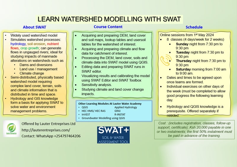
Learn Watershed Modelling with SWAT -
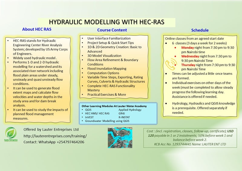
Hydraulic Modelling with HEC RAS -
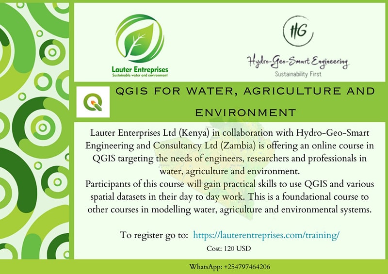
QGIS for Water Agriculture & Environment